
Since its formation on June 6 in the southeast Arabian Sea, Biparjoy had maintained a northward track, gathering strength and becoming an extremely severe cyclonic storm on June 11, packing wind speed of more than 160 kmph, and then losing intensity a day later.

IMD Director General M Mohapatra said there is cyclonic circulation along the Karnataka coast which is hindering the progress of the southwest monsoon.

The drought of 2009 still haunts the India Meteorological Department.

Although the monsoon is not active, it is not sluggish either he said, adding that the eastern coast, central India and north east are getting fairly good rains. Even Maharashtra and parts of peninsula are having rain.

Addressing a press conference virtually, India Meteorological Department Director General Mrutyunjay Mohapatra said September was likely to witness normal rainfall in the range of 91-109 per cent of the long period average of 167.9 mm.

The much-awaited south-west monsoon on Monday brought first showers to the Andaman and Nicobar islands, setting the stage for its early progression towards Kerala.The onset of monsoon has now set the stage for the four-month rainfall season that has been eagerly awaited by the agricultural community who had to bear the brunt of a severe drought last year.The weather office said conditions were favourable for further advancement of the monsoon over more parts of Bay of Bengal
The Southwest monsoon, crucial for agriculture across the country, has entered a weak phase and is expected to revive in the next two days. The weathermen have forecast strong westerly winds over the peninsular region, which is expected to aid the advance of monsoon in the next two days. Monsoon is expected to reach Mumbai by June 10.

According to Indian meteorological department, tremors were felt in Bihar, Uttar Pradesh, Jharkhand, Rajasthan, Haryana and Punjab, lasting for a minute, triggering panic and forcing people to rush out of their homes and offices. There was no official word about casualties from any of the states but reports from West Bengal said cracks appeared in several multi-storeyed buildings in Siliguri in north Bengal. An incident of wall collapse was reported from Telipara in Jalpaiguri district.

It is in more than a decade that the IMD has predicted 'above-normal' rains in the country.
India, hit by a devastating drought last year that hurt economic growth, is expected to experience a below normal monsoon this year.

Very heavy rainfall is likely to occur at one or two places in Kerala on Wednesday.

The low-pressure area over the South Andaman Sea and adjoining southeast Bay of Bengal is very likely to move northwestwards and intensify into a depression by Saturday, the weather office said.

According to the IMD, a rain event is categorised as a cloudburst if a weather station receives 100 mm of rain in one hour.

India will launch its own composite index next year to quantify the impact of heat on its population and generate impact-based heat wave alerts for specific locations, the India Meteorological Department (IMD) has said.

With temperatures remaining above normal since November, this winter could well be the warmest ever recorded not only in North India, but across the country.

Scores of people die every year due to cold waves that sweep across the north Indian plains.

Brace for some warmth this winter as the India Meteorological Department (IMD) in its December-February forecast on Thursday said that the minimum and maximum temperatures could remain 'normal' to 'above normal' over most parts of Northwest and Northeast India. Both the minimum and maximum will remain below normal in Southern Peninsular and Central India in these winter months. While this could give some respite from the intense cold of North India, it could have a negative impact on the standing rabi crops if the temperature rise is unusual and abnormal.

He said scientists have noticed a trend of very deep cloud systems developing over the southeast Arabian Sea, and added that sometimes, these systems intrude into the land, like in 2019.

At present, the Met department is often unable to provide exact information on the exact amount of rain over a localised area.

Mohapatra said there is a 40 per cent chance of a normal rainfall, 22 per cent above normal, 12 per cent excess and 18 per cent below normal.

The system lay centered at 5.30 am over Southeast Bay of Bengal, about 450 km west-northwest of Car Nicobar (Nicobar Islands), 380 km west of Port Blair (Andaman Islands), 970 km southeast of Visakhapatnam (Andhra Pradesh) and 1030 km south-southeast of Puri (Odisha).

The state broadcasters have started the practice, but private news channels may follow suit, a ministry source said.

The Odisha government has asked all the district collectors to remain prepared for any eventuality, and directed the administration to evacuate people from low-lying areas in the event of heavy rain.

The World Meteorological Organisation/Economic and Social Commission for Asia and the Pacific Panel on Tropical Cyclones, at its twenty-seventh session held in 2000 in Muscat, Oman, agreed to assign names to the tropical cyclones in the Bay of Bengal and Arabian Sea.

At the review meeting, chaired by cabinet secretary Rajiv Gauba in New Delhi, the IMD said above normal maximum temperatures are likely over most parts of northeast, east and central India and some parts of northwest India.

NDRF, with the help of local authorities and police, has been conducting evacuation operations to minimise the potential damage from the cyclone.

Apart from the metropolis, several other parts of Maharashtra also reported a drop in night temperatures, resulting in chill and cool breeze in those areas.

El Nino is often associated with below average warmer, dry weather across Asia Pacific region.

A total of 435 people died in the country due to extreme weather events during the last three months of the southwest monsoon, according to the data compiled by the India meteorological department.
The department said Marathwada, Central Maharashtra and Central India will benefit the most.
The IMD chief also allayed fears of occurrence of an El-Nino.

The southwest monsoon is set to make its exit in style, bringing rains to the parched parts of Uttar Pradesh and Bihar, as weather forecasters have picked up signs of formation of a cyclonic circulation over Bay of Bengal. Addressing a press conference in New Delhi, India Meteorological Department (IMD) director general Mrutyunjay Mohapatra on Thursday junked last week's forecast of early withdrawal of southwest monsoon and announced the extended stay of the seasonal showers. "Even though we expected early withdrawal of the southwest monsoon, a cyclonic circulation over west-central and adjoining northwest Bay of Bengal will shift the monsoon trough southwards around September 7.

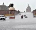
The IMD had said the Southwest Monsoon would hit parts of north India including Delhi on July 10, but it had not occurred till Sunday evening.

An NDRF team has a strength of about 45 personnel and each unit is equipped with tree and pole cutters, communication gadgets, inflatable boats and a small basic medical unit.

Odisha is bracing for heavy rainfall early next week under the impact of a possible cyclone in the Bay of Bengal, which is likely to skirt the state and move towards West Bengal and Bangladesh, the Indian Meteorological Department (IMD) said on Friday.

India is set to experience extreme heat during the April to June period, with the central and western peninsular parts expected to face the worst impact, the IMD said on Monday as the country prepares for seven-phase general elections from April 19.

The IMD has forecast heavy rainfall in some parts of the state in next 48 hours. "The southwest monsoon has arrived in Maharashtra. The onset line is passing over Harnai, Solapur, Ramagundum (Telangana) and Jagdalpur (Chhattisgarh)," IMD Mumbai centre's deputy director general K S Hosalikar said.